Packaging information
CTN Szie: 40 × 30 × 30 cm
G.W./CTN:9 kg
QTY/CTN:48 set/carton
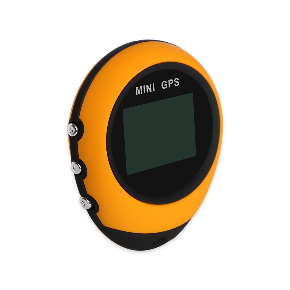
This product is an ultra-small volume, easy to carry, handheld Global Positioning System mini receiver, with longitude and latitude coordinate indication and guidance, allows users to return to the original starting point or to the pre-set target point at any time needed. During The guiding process, this product provides the geographical coordinates of the current location, the direction and distance of the target place, the satellite time, clear Travel data such as travel speed and sea dial height are personal outdoor travel adventure companions.
Way Finder product overview:
i. Main functions of the product
- to light and easiest to operate GPS!
- Store up to 16 points of interest!
- Return to the starting point or guiding destination!
- Real-Time latitude and longitude coordinates of!
- Travel distance of the time!
- Travel speed and poster height!
- The satellite time!
- Can you easily find the scenic spots you want to reach, and can you easily find the location where you park your car......?
The key operating instructions
1. Recognizes that the key
* In the shutdown state, press the confirm key for three seconds to turn on. In any mode or page, press the confirm key for three seconds to turn off.
* The Machine opens page 1 and presses the confirm key to switch back to 16 points of interest.
* The Machine opens page 2 and presses the confirm key to calculate the mileage and time.
* The Machine opens page 6, press the confirm key to enter the Back Light (backlight setting) of the sub-page, press the confirm key again to enter the setting selection item (that is, enter the sub-page of the lower level), the selected item will be displayed in reverse White. Press the confirm key again to confirm the selection and return to the previous layer. If there is no operation, return to the main page 5 seconds later.
* Points of interest refer to points marked on the map, with latitude and longitude information, which can be used to find and calculate navigation punctuation and buildings.
2. The up arrow
* Six pages are switched down
* When page 6 Settings is displayed, press the confirm key to enter the sub-page, press the confirm key again to enter the setting selection item (that is, enter the sub-page), press the up button to change the parameter settings
3. The down arrow
* The operation is exactly the same as the up key.
Browse operation page
users need to use the guide to guide all relevant data displayed on the Main Page. To browse these pages, when the product captures satellite signals and sets them in place, press the up key or down key repeatedly to find another page from one page.
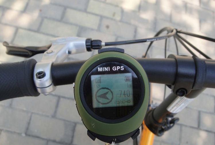
Page 1 (main page): displays satellite signal reception strength, remaining battery capacity, point of interest record order and time, and mileage and direction from the current location.
Page 2 (travel information): displays the time that has been used in the trip and the mileage traveled. Press the confirm key briefly, next to the signal ladder in the upper left corner, a villain icon appears and starts to record the mileage and time information of your trip. Press the confirm key again. The villain icon disappears and the record stops.
Page 3 (longitude and latitude coordinates): displays the geographic longitude and latitude coordinates of the current location.
Page 4 (speed and altitude): displays the current traveling speed and relative altitude.
Page 5 (satellite time): displays accurate real-time satellite synchronization time
page 6 (settings page): provides setting operations such as backlight continuous display time, time zone, and point of interest deletion.
Point-of-interest satellite positioning
1. In the environment where there is no building with an elevation angle of 15 degrees around the open area of the outdoor sky, the front hand-held Guide opens the machine. After entering page 1 (main page), the signal level 4 ladder in the upper left corner shows the signal strength, if the satellite is not searched, there is no signal ladder. One column indicates searching and receiving three satellite signals, two indicate four satellites, three indicate five satellites, and four indicate six or more satellites. Two or more cylindrical bars are required for positioning, and the more accurate the super-strong signal positioning is. Start a cold start in a strange environment and when it is not used for a long time. The search time of the star limit signal is about 2 minutes, the position deviation is not large, and the shutdown time is not long. For example, start again within 2 hours, about 40 seconds, it takes about 1 to 2 seconds to shut down or lose the signal for a short time and start again to hot start.
2. When the intensity of the signal bar shows two or more, press the confirmation key and the up key or the flute down key for three seconds at the same time, and lock the current position as the first light point, the order of information points is displayed on the left (1), and the time when the interest point is locked is displayed on the right. The user can return to the set point of interest by using the direction and distance indicated by the arrow icon in the lower left corner during movement.
3. Short press the confirm key to find the next point of interest, and short press the confirm key and lock the current position up or down as the second point of interest, which can determine 16 points of interest in turn. Each point of interest displays the set date and time. The user can confirm the location of the point of interest according to the set time.
4. Press the up button or down button for three seconds to enter the longitude and latitude coordinate change page. The first value of longitude and latitude is displayed in reverse White. Press the up button or down button for a short cycle to select the position to be changed, press the confirm key to change the number 1-9. The last N represents North latitude, S represents south latitude, E represents Tokyo, and W represents western longitude. You can use Google Maps to find the longitude and latitude coordinates of the target location in advance and enter this machine according to this operation. After the setting is completed, press the up button or the down button for three seconds to save the setting and return to the main page, if there is no operation, return to the main page after 10 seconds.
System Settings
1. Enter page 6 Setting, press the confirm key to enter the Back Light Time Setting page, and press the up key or the down key to enter the Time Zone in turn, measure Unit, Clear POI, Cold Start Reset Default, and finally return to Setting, return to the main page after 5 seconds.
2. After entering the Back Light time setting page, press the confirm key to enter the backlight time selection page. Press the up key or the down key to display the time in reverse White: 5(s),10(s),30(s),60(s),Infinite respectively represent the backlight continuous display time 5 seconds, 10 seconds, 30 seconds, 60 seconds, constant brightness. After you press the confirm key to confirm the final selection, the time is displayed normally.
3. After entering the Time Zone setting page, press the confirm key to enter the Time difference value page to select the Time Zone. Press the up key or the down key. The Time difference value will be displayed in reverse White:-12,~,+13 represent the values of time difference with Greenwich time respectively. Select the value of the time difference between the local time zone and Greenwich Time, and press the confirm key to confirm the final selection. The time difference value is displayed normally.
4. After entering the Measure Unit setting page, press the confirm key to enter the measurement Unit selection page, and press the up or down key to display the measurement Unit in reverse White: km mile represents kilometers and miles respectively. Select the desired unit of measurement, and press the confirm key to confirm the final selection. The unit of measurement is displayed normally.
5. After entering the Clear POI page, press the confirm key to enter the point of interest selection page, press the up key or the down key, and select to display the reverse White: YES,NO represents Yes and NO respectively. Select whether to clear all points of interest. Press the confirm key to select YES. All points of interest will be cleared. YES is displayed normally.
6. After entering the Cold Start page, press the confirm key to enter the Cold Start selection page. Press the up or down key to select the anti-white display: YES/NO represents YES and NO respectively. In unfamiliar environments and long-time unused situations, please select YES, which helps to clear the old satellite-related information that has been retained, improve the re-search speed and press the confirm key to select YES. This product will automatically shut down and restart, and the old satellite related information will be cleared.
7. After entering the Reset Default page, press the confirm key to enter the factory initial Default settings page. Press the up key or the down key to select anti-white display: YES/NO indicates YES and NO respectively. Select whether to reset the factory default settings. Press the confirm key to select YES. All settings will be reset to the original factory default settings.
Pay attention to matters
1. Under the same point of interest page, the second lock point of interest will overwrite the first information. To retain the original point of interest, you must switch to the next point of interest and then locate the next point of interest.
2. This machine can only calculate and provide accurate direction indication information when you keep moving at a certain speed.
3. In order to save electricity, please turn off the machine after determining the orientation and direction of travel. After a period of time and distance travel, you can turn on the machine again when the orientation and direction need to be determined again.
- To light and easiest to operate GPS!
- Store up to 16 points of interest!
- Return to the starting point or guiding destination!
- Real-Time latitude and longitude coordinates of!
- Travel distance of the time!
- Travel speed and poster height!
- The satellite time!
II. Technical indicators
receiver: L1 type, C/A code, capture Channel: 51, tracking Channel: 14,
the biggest update frequency:10Hz,
shows like rate: 128*64,
the backlight type: blue
appearance size:65*52 * 21mm
weight:39.6g with battery,
memory:512KB,
keys:3 keys,
accuracy: positioning, 10 meters (support differential correction system Area 2 meters), speed, 0.1 metre per second,
the first positioning Time: hot start is about 5 seconds, warm start is about 40 seconds, cold start is about 2 minutes,
sensitivity:-161dbm tracking,-157dbm re-capture,-148dbm capture
data Protocol: NMA-0183 v3.01
power supply voltage: USB DC 5V/3.7V 390 mA built-in lithium battery
operation Duration: about 6 hours